
Run a Mercer County Property Search
The WV Property Assessment application is the main door into a Mercer County property search. It offers Basic, Appraisal/Sales, Advanced, and Prior Ownership modes. Choose Owner Name when the street is unknown. Use it too when one party may hold several parcels. Choose Street Name for an address lead. Then check the returned Property Address and district against what you expect. A district/map/parcel entry or a Full Parcel ID narrows things fast. The statewide WV Property Viewer covers the map side. It adds E-911 address, parcel-attribute, geometry, and coordinate searches.
The cleanest route runs from address or name to the assessor parcel. From there, move to the full identifier, map, and deed reference. That order keeps you from pairing the wrong house with a lookalike street. Save each query and its date, since the tax roll refreshes on its own cycle.
- Choose Mercer County and enter the owner, street name, map, parcel, or full ID you know.
- Compare each result's Property Address, district, map, parcel, acreage, and land-use fields.
- Open the detail page and save the full ID, legal description, and deed book/page.
- Confirm the physical setting in the WV Property Viewer and compare the latest recorded deed with the roll.
- Ask the County Clerk for a copy of the recorded instrument when the index or image is not online.
Mercer County Owner Name Searches
Owner Name is the right tool when the address is unknown, when an owner has moved, or when several parcels may share a name. Try a surname with and without an initial. Enter a company or trust name exactly as it appears on a tax record. The WV Property Assessment system accepts owner queries, but treat any result as a lead rather than proof that every interest is listed, because an LLC's registered agent or mailing address can differ from the property location.
Too many records? Add a District or Street Name filter. No records at all? Drop punctuation, shorten a business suffix, or try a spelling variation. For a trust or estate, compare the assessor entry against the deed's grantee field and any probate transfer. The West Virginia business search helps identify the entity behind a company owner, though the latest recorded deed remains the true land-transfer source and does more than any entity listing to establish current title.
What a Mercer County Search Result Shows
Each Mercer County result row carries a defined field set. That field set ties a name to land. Expect Root Parcel ID, Current Owner, Property Address, County, District, Map, Parcel, Map Link, Flood Tool, Deeded Acres, Property Class, Land Use Code, Tax Class, Building Appraisal, Land Appraisal, and Total Appraisal. The detail page goes further than the short row. It can list multiple owners along with the mailing address. That makes it worth opening whenever ownership questions remain.
| Current Owner | Name attached to the assessment roll; detail can show joint owners. |
|---|---|
| Property Address | Physical situs address, separate from the owner's mailing address. |
| District / Map / Parcel | Tax-map identifier; some maps are lettered and parcel values may be decimal. |
| Deeded Acres / Class | Area and property classification shown on the roll. |
| Land / Building / Total Appraisal | Separate appraisal amounts for the current tax cycle. |
| Deed Book / Page | Cross-reference to a recorded instrument held by the County Clerk. |
A result row has limits. It does not resolve every claim, lien, mineral reservation, or prior conveyance. It does not certify a boundary line. The assessment system exists to organize property for tax administration. For the instrument itself, use the deed book and page. For a legal boundary, rely on a recorded plat or survey.
Search Mercer County Streets by Name
The Assessor screen offers Street Name rather than a guaranteed full-address match. Start with the core road name and select Mercer County. A broad list narrows with district, map, parcel, or tax class. Read the Property Address column. Do not assume a mailing address shown elsewhere marks the site.
Rural routes, renamed roads, old community labels, and city mailing names often differ from today's E-911 label. The difference is rarely word for word. Try a shorter road form. Then confirm the parcel through deeded acres, district, map, owner, and legal description. An address is a locator, nothing more. When the exact road name is a guess, drop an approximate point or coordinate into the WV Property Viewer. Carry the resulting parcel key back to the Assessor search.
Mercer County Search Keys by Address
Start with whichever key is most reliable. A current address is easiest, an owner name surfaces multiple holdings, and the full district/map/parcel ID gives the most exact match across county systems. Use one key to find the others, then save all of them together.
| Search Key | Best For | Where It Works | Watch Out |
|---|---|---|---|
| Street name | Locate a known site or block | Assessor and WV Property Viewer | Mailing and situs addresses can differ. |
| Owner name | Find parcels tied to a person or entity | Assessor; Clerk deed records | Try name forms and entity variants. |
| District / map / parcel | Match one exact tax parcel | Assessor, Viewer, map-card tools | Copy letters, decimals, suffix, and zeros. |
Not a title search. An Assessor result identifies a tax-roll entry, not every ownership interest or lien. Review the recorded deed chain and consult a title professional or attorney when title must be established.
Fields in the Mercer County Property Search
The WV Property Assessment search runs in Basic, Appraisal/Sales, Advanced, and Prior Ownership modes. Its fields let you narrow Mercer County property records without assuming a street or surname is unique. Most fields are optional unless county selection or the portal context supplies them.
| Field | Type | How to Use It |
|---|---|---|
| County / District | Dropdown | Select Mercer; district narrows the tax-map area. |
| Full Parcel ID | Text | Enter the complete IAS-style identifier. |
| Owner Name | Text | Try surname, company, trust, punctuation, and spelling variants. |
| Street Name | Text | Search the road name, then verify Property Address. |
| Map Number / Parcel / Sub-Parcel | Text | Use the exact map and parcel parts shown in a result. |
| Property Class / Tax Class / Land Use | Dropdowns | Filter by the roll's classification or land-use code. |
| Min/Max Land, Building, Total Appraisal | Numbers | Set a value range for the relevant appraisal field. |
| Min/Max Calculated Acres | Numbers | Narrow parcels by calculated area. |
| Sale From / Through | Dates | Set a date range in Appraisal/Sales mode. |
| Min/Max Price | Numbers | Filter the portal's sale-price range; check the deed separately. |
| Min/Max Deeded Acres | Numbers | Compare the deeded acreage field. |
| Flood Hazard | Dropdown | Use as a screening clue, then confirm with the proper source. |
| Mailing Address | Text | Search correspondence address, not the parcel's physical location. |
| Deed Book / Page | Text | Carry a known recording reference into the roll search. |
| Legal Description | Text | Search a phrase from the written tract or lot description. |
| Building Year Min/Max | Numbers | Limit results by the building-year fields. |
| Primary / Secondary Structures | Numbers | Filter by structure count. |
| Building Area Min/Max | Numbers | Set the shown building-area range. |
| Lines per Page | Number | Change result-page size. |
| Display Legal Description / GIS Parcel ID | Checkboxes | Add the selected values to the result display. |
Enter one or two fields, then narrow only after reviewing what returns. The portal displays matching-record totals, page count, the query URL, a Property Viewer link, and CSV Results. Dropdown options and any required-field rules may vary by mode, so let the results guide the next filter.
Mercer County Appraisal and Sale Filters
The Appraisal/Sales mode filters by land, building, and total appraisal ranges. Calculated acres, deeded acres, sale date, and price round out the controls. Use them when a street lookup drowns you in parcels. They also work for comparing records in one district. Keep the filter conditions with any CSV export. Anyone can then rebuild the list.
A portal sale field is only a lead toward a transaction. It is never a substitute for the recorded instrument. The portal does not say which transfer types feed the sales fields. It also does not say whether every consideration amount appears. For a specific transfer, take its date to the County Clerk. Look for the deed there. Match the legal description and parcel ID there. The Assessor's July 1 snapshot lags too. A recent sale may not appear in a 2026 ticket roll.
Open Mercer County Parcel Detail
A search row can list a single owner even when the parcel has several. Check vesting in the detail record, not the search row. For a Mercer parcel, the detail route can show owner names and parcel identifiers. Value fields and the physical location appear there too. Links to related assessment information sit alongside. Read the mailing address separately. A bank, trustee, or out-of-county mailing entry does not establish where an owner lives.
After a search, the result page offers a view in Property Viewer and CSV Results. Use CSV as a working list for a parcel group. Then click through each item that matters. The map view can resolve a rural road label. It can also clarify a parcel beside a shared line. It is not a survey or a title opinion.
The WV assessment detail example shows the separate owner, parcel, and value information. That detail opens after you click a result.
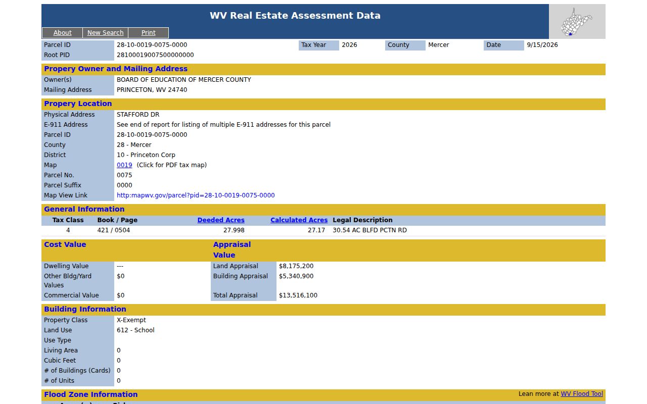
Capture the full parcel key in the detail view first. Then take it to the county map or the recorded deed for checking.
Lettered Maps in Mercer County Searches
Mercer County examples include a lettered map such as 16V and a parcel value such as 58.0. Those characters are not decoration. Copy the complete value from the Assessor result, including any suffix and the leading zeros the statewide identifier uses. The map-card page asks for District and Map/Parcel. Carry the same segments over without shortening them.
The Property Viewer describes an IAS-style format with padded district, map, parcel, and suffix fields. A visible root ID starts with 28 for Mercer in the statewide display. The human-readable pieces are easier to compare against a PDF tax map. The whole ID suits a single-field portal. Never guess a number for lettered or decimal segments.
The Mercer County assessment search packs every search mode together.
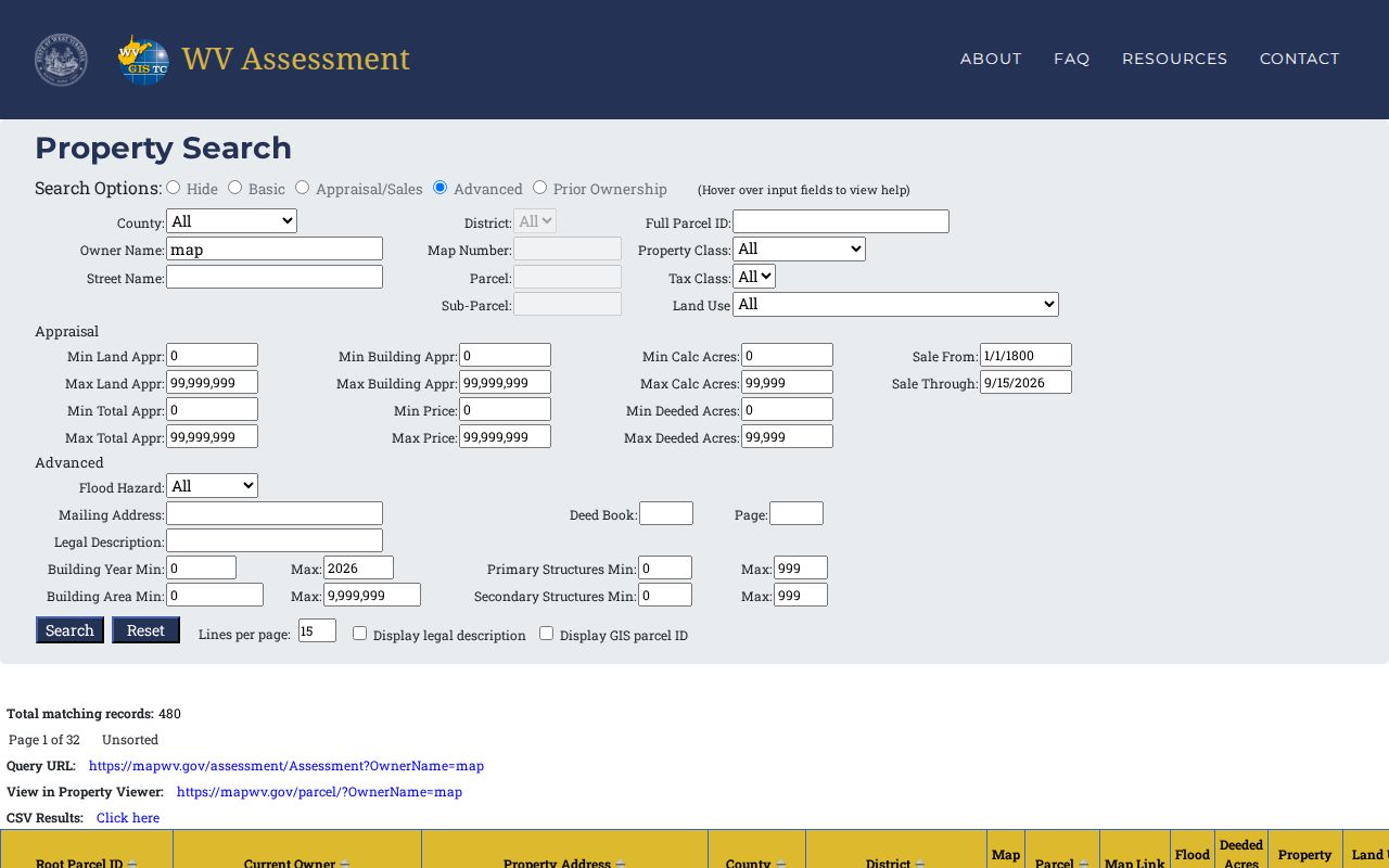
Narrow the results with search modes, then verify in parcel detail.
When a New Mercer Sale Is Missing
The Assessor says the 2026 tickets use a July 1, 2025 assessment date. A later sale may not appear yet. A property search can therefore return the prior owner after a more recent conveyance. Check the recorded deed at the County Clerk. Keep both dates when contacting the Assessor.
Never read the tax roll's last update as the deed's recording date. The Assessor runs its own roll cycle. The Clerk records instruments as presented and accepted. A recent deed may also carry a trust, executor, or entity name that differs from the previous owner spelling. Match the legal description and parcel ID along with the names.
Mercer County Deed Book and Page Handoff
A deed book and page is your handoff. Use that reference to request the recorded document from the Mercer County Clerk. The Clerk is the recorder for conveyances, deeds of trust, releases, assignments, easements, plats, liens, and other land instruments. The Assessor portal is no grantor-grantee title index. The Clerk offers no public online index. No earliest indexed year is published either. When you write, provide the parcel, owner names, approximate date, and the reference already shown. Ask whether inspection, an ordinary copy, or a certified copy is available and what the fee is. Recording rules govern filings, not record copies. The separate Mercer County deed records information explains the recording office and its access gap.