How to Search Mercer County Property Records
Different offices hold Mercer County property records because each record answers a different question. Start with the question. For the tax-roll owner, situs address, parcel key, acreage, class, or appraised value, use the West Virginia Property Assessment search. Use the Property Viewer for location and parcel shape. The Mercer County Clerk serves as recorder. Deeds, deeds of trust, releases, liens, easements, and plats all live in that office. The Sheriff collects current taxes. Once delinquent land is certified, the State Auditor's Land/County Collections system becomes the relevant search.
One result is a lead, not a title opinion. The assessor labels its field Current Owner. That online roll is built for a tax ticket and can trail a later transfer. A tax map helps identify a tract, yet it is no boundary survey. Match district, map, parcel, and suffix exactly. Then compare the record date, deed book and page, legal description, and map before relying on the result.
- Search WV Property Assessment by owner name, street name, or known district/map/parcel. Select Mercer County and keep the physical address separate from the mailing address.
- Save the full parcel identifier, deed book/page, legal description, and result fields. Open parcel detail when joint ownership may be present.
- Use WV Property Viewer or a Mercer PDF tax map to check the parcel's setting, then carry the deed reference to the County Clerk.
- Ask the Mercer County Clerk for the recorded instrument and related liens or plats. The assessment result is not a grantor-grantee deed index.
- Check current taxes with the Sheriff's Tax Office. For land already certified to the state, search the Auditor's Land/County Collections records.
Mercer County Property Records Offices
Most county desks cluster near one another at 1501 West Main Street in Princeton. They share no combined index, though. Start with the office that created the record. Bring the parcel key, record type, and date range. Mercer County offices generally post weekday hours near 8:30 a.m. to 4:30 p.m., so confirm current hours and phone numbers on the office page before traveling.
Mercer County Clerk
1501 West Main Street, Suite 121
Princeton, WV 24740
304-487-8312
Mercer County Assessor
1501 West Main Street, Suite 110
Princeton, WV 24740
304-487-8397
Sheriff's Tax Office
Mercer County tax collection
1501 West Main Street, Princeton
Confirm current tax contact
WV State Auditor
Certified delinquent land and sale records
Statewide Land/County Collections
Online search
Vital records are a related county service, not land-title records. Birth, death, and marriage copies are different. West Virginia routes certified copies through its Vital Registration program. Eligibility, identification, delivery options, and the posted $12 fee sit outside the County Clerk's deed recording process.
The West Virginia Vital Registration instructions show the application channels and identification steps for copies connected with Mercer County residents.

Mercer County's July Assessment Snapshot
The Mercer Assessor states that the 2026 tax tickets rest on an assessment date. That date is July 1, 2025. The notice carries a warning. A sale after that date may not show up in the current ticket data. Other changes can lag too. The next update is expected on or about July 15, 2027. That beats assuming an online owner field changes the day a deed is signed.
After a recent closing, check two things. Compare the Assessor's Current Owner field with the newest deed the County Clerk recorded. For value questions, keep the ticket year beside the land, building, and total appraisal fields. Dates matter here. The assessed figure is a tax measure, not market price. It follows West Virginia's 60 percent assessment rule. A record can be accurate for its tax cycle and still lag a newer deed.
The roll is a snapshot. Deeds move faster. Read the current notice on the Mercer County Assessor site. Treat the roll as current to a particular transaction only after that.
From a Mercer County Address to a Parcel ID
An address is a fine first clue. Mercer County property records are actually keyed through district, map, parcel, and sometimes a suffix. Statewide identifiers begin with the Mercer county code 28. Visible examples include Beaver Pond District map 20, parcel 180.0, and East River District map 16V, parcel 58.0. Lettered maps and decimals are part of the key. Copy them exactly. Never force them into a numeric-only form.
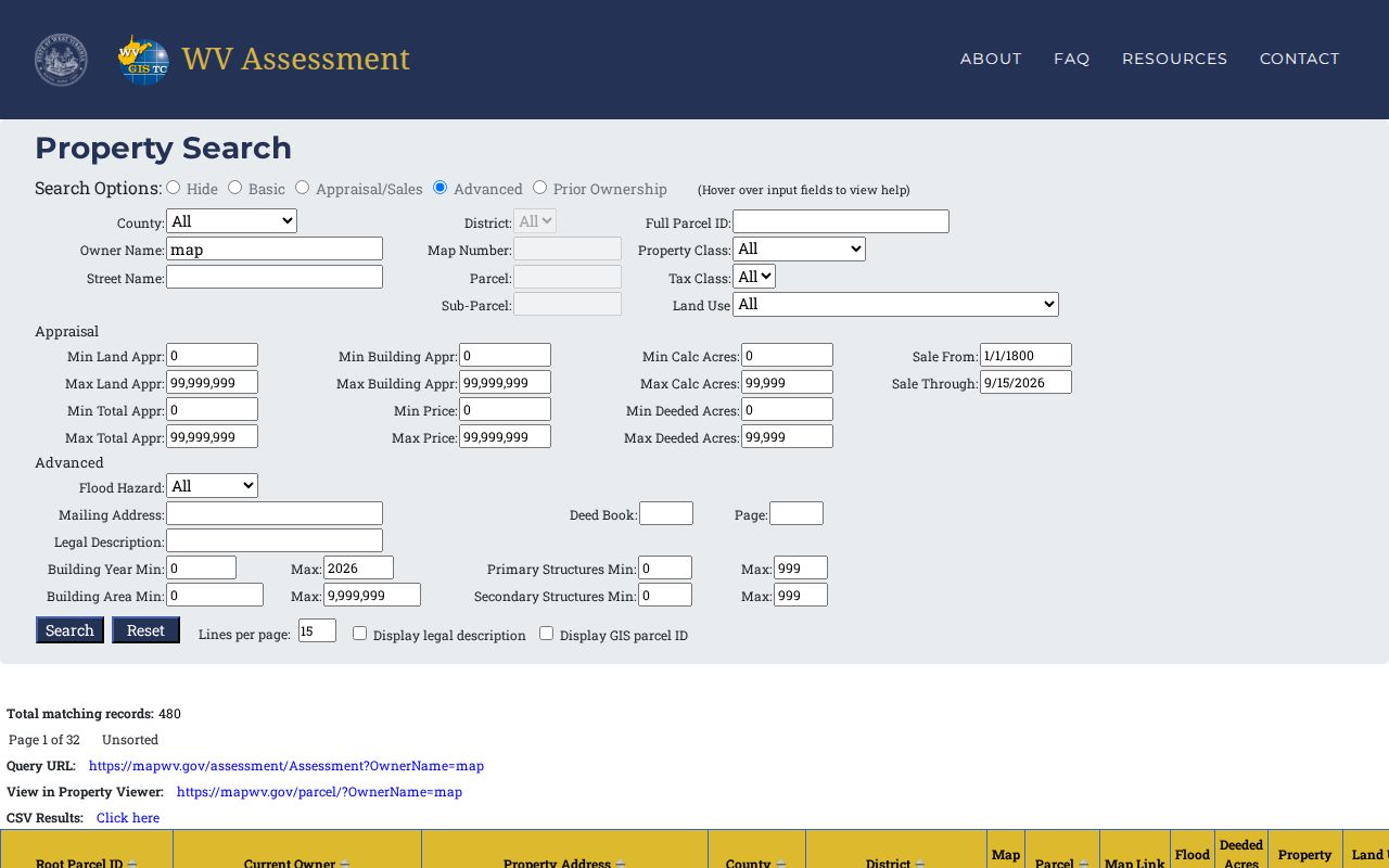
The Assessor search splits entry into separate fields for Street Name, Owner Name, County, District, Full Parcel ID, Map Number, Parcel, and Sub-Parcel. There is no single exact full-address box. A road suffix or old road name can block a match. Try a shorter street phrase. Then confirm the physical Property Address in the results and compare district and acreage. A mailing address may belong to an owner or lender elsewhere, so never use it to place the land.
- Parcel ID
- The county tax-map key, built from district, map, parcel, and suffix parts.
- Situs or physical address
- The location of the land, distinct from the owner's mailing address.
- Legal description
- The deed's written description of the tract, lot, or boundary calls.
- Plat
- A recorded map of lots, roads, and shared features in a subdivision.
Types of Mercer County Property Records
Mercer County property records span tax-roll data and recorded title instruments. They also cover parcel maps, court cases, municipal files, and delinquent-land notices. None replaces the others. Each answers its own question. The Assessor result can point to a deed book and page. The Clerk keeps the instrument itself. The map adds geographic context but settles no title or boundary dispute.
| Record Type | What It Documents | Kept By | Access |
|---|---|---|---|
| Deeds and title instruments | Transfers, trust deeds, releases, plats, easements, and liens | Mercer County Clerk | Request from Clerk; online index not verified |
| Assessment and tax roll | Owner field, parcel key, class, acres, land/building/total appraisal | Mercer Assessor | Free statewide assessment search |
| Tax collections | Current tickets and payment status | Sheriff's Tax Office | Confirm current lookup with office |
| Parcel maps | Tax-map geometry, map labels, and adjacent parcels | Assessor and WV Property Viewer | Viewer and PDF map pages |
| City-use files | Zoning, permits, inspections, annexation, code cases | Princeton or Bluefield | City pages and direct requests |
Match the record to the question first. The Assessor's tax roll carries each parcel's appraisal and tax classification. The County Clerk's recorded deeds settle legal ownership questions. When the issue is a bill or a delinquency, the tax collector is the right office. An appraisal figure says nothing about payment status. Princeton and Bluefield keep their own regulatory files. The county stays the owner and deed-record keeper, though, so title work still runs through its deed books. The Mercer County deed records page walks through the recording route. Tax figures and collection steps sit in Mercer County property tax records.
What a Mercer County Assessment Result Returns
A result from the WV Property Assessment works like an index card for the parcel. It goes well beyond a name beside a value. Fields can include the Root Parcel ID, Current Owner, Property Address, County, District, Map, Parcel, Map Link, Flood Tool, Deeded Acres, Property Class, Land Use Code, Tax Class, Building Appraisal, Land Appraisal, and Total Appraisal. The detail view may list multiple owners. It may also show more parcel data than the one-line result shows.
One sample East River row carried map 16V, parcel 58.0, 0.35 acres, class R, land-use code 101, tax class 2, and a total appraisal of $349,200. That total was split between building and land. Another Beaver Pond example showed map 20, parcel 180.0, and 0.61 deeded acres. Treat these as sample rows. They say nothing about a particular owner's title. Use the fields to identify the record, then read the deed and check its recording date.
The search also returns appraisal and sales ranges, a mailing address, deed book and page, legal description, building year, structure counts, and building area. A CSV export can serve as a working list. Pair any export with the query and date, though. The roll shifts with each new tax cycle.
| Current Owner | Assessor's owner-of-record field for the tax roll. |
|---|---|
| Property Address | Physical location, not necessarily the mailing address. |
| District / Map / Parcel | Core locator for matching maps and county records. |
| Land / Building / Total Appraisal | Separate tax-value fields shown in the result. |
Why a Mercer County Tax Map Is Not a Survey
The WV Property Viewer builds its parcel geometry from assessor mapping data, and Mercer County also publishes reduced and full-size PDF tax maps by district and map. The county's Map Card Viewer lets you pick District and Map/Parcel, though it notes that copies of map cards require a visit to the Assessor's office. The statewide viewer adds address search, parcel-attribute search, geometry search, coordinates, an identify tool, and CSV or KMZ exports.
A tax map is a finding aid. It helps locate a tract, compare neighboring parcel keys, and tie an address to a plat or deed. It is not a survey. The statewide viewer itself cautions that some assessor geometry is still paper-based and may take years to convert, so a rough or missing outline never proves a parcel is absent. For a boundary question, compare the recorded plat and the deed, and bring in a licensed surveyor when a legal line must be marked.
Note: Mercer map cards and statewide GIS reports serve different needs, so ask the Assessor for a paper copy when the viewer lacks a needed detail.
Mercer County Property Records at City Limits
A Princeton or Bluefield mailing address does not prove a parcel sits inside the corporate line. County tax records reach beyond the incorporated boundaries. City zoning, inspections, and code rules apply only where the municipality holds jurisdiction. County GIS and state transportation maps separate Princeton, Bluefield, Athens, Bramwell, Matoaka, and Oakvale from the surrounding county.
Princeton publishes eight zoning categories and links a Citizen Portal for code requests. Bluefield Engineering/Planning handles permits, occupancy, plat review, annexation, rezoning, and site plans. Athens lists a municipal clerk/recorder contact with the West Virginia Secretary of State. But the city publishes no permit portal or current subdivision roster. City-specific routes are detailed on the Bluefield records page and the Princeton records page.
Mercer County Owner Field Versus Deed
The Assessor's Current Owner label reflects the name tied to the tax roll. It is useful for finding a parcel and its tax account. It is not the transfer instrument. A recorded deed plays that role. A deed signed after July 1, 2025 may fall outside the data Mercer says it used to prepare the 2026 tickets. That can make the tax roll look older than a newly recorded deed. Neither record is a full answer to every title issue.
For a current ownership check, note the date on the assessment detail. Note the deed book/page reference there, too. Then ask the County Clerk for the newest conveyance. Also ask about any later releases, deeds of trust, easements, or liens. A lien or mineral reservation can still matter. The surface owner field may look clear. Probate may add an estate or fiduciary transfer between the last tax update and a later deed, too.
Mercer County Parcel Districts and Maps
District is part of a parcel's identity in Mercer County. Statewide examples include Beaver Pond and East River. GIS materials also identify a Bluefield Corporate District. A city, a tax district, and a mailing town describe related but different geographies. Carry the exact district from the assessment result into any map search. Never infer city limits from the district label alone.
Some Mercer map numbers include letters, and parcel entries can carry decimals or suffixes. The viewer's format pads district, map, parcel, and suffix segments into an IAS-style identifier. Copy the whole ID exactly. Do not drop leading zeroes or change punctuation. When two candidates share a street name, compare the legal description, acres, owner, and GIS location before choosing one. Compare all of it before choosing one.
Mercer County Delinquent Property Records
Delinquent taxes follow a two-step path. Current collections belong to the Mercer Sheriff's Tax Office. But once land is certified delinquent, the West Virginia State Auditor's Land/County Collections system takes over. That system tracks the tax-sale trail and the steps after certification. Search it by county, district, map, parcel, sub-parcel, certificate, taxpayer, purchaser, bidder, description, ticket, account, or status. The Auditor page also posts land-sale pre-registration along with notices and forms.
State law sets the timeline. Under W. Va. Code §11A-3-44, the Auditor certifies lands for sale between March and August. A $25 preparation charge is added. Section 11A-3-46 requires auction notice once a week for three straight weeks. Even so, a delinquency can still involve notice and redemption steps. An Auditor deed comes only afterward. Match the parcel in the Auditor system. Confirm current instructions with the Sheriff. Check recorded instruments with the County Clerk.
For certified delinquent land, use the official WV Auditor Land/County Collections search. It is not the ordinary current tax-ticket portal.
Mercer County Property History in Old Maps
Mercer County dates to 1837, carved from Tazewell County, Virginia. Old land descriptions can cross the statehood line in their wording. They may cite creeks, company tracts, coal camps, rail corridors, or a community name. That name may no longer match any current road address. No courthouse fire or destroyed deed-book run is on record here. So an assumed records loss should never explain a gap in a deed search.
When an old description fails a street search, carry the working details forward. That means the grantor, grantee, deed date, book and page. It also means acreage, district, map, parcel, lot, block, and any exceptions. The Mercer County Historical Society offers appointment-based access to maps, plat books, cemetery records, and newspapers. It also holds church and school registers, and family files. The State Archives catalog and FamilySearch add further leads. Their catalog entries help locate material but never replace the Clerk's recorded document.
West Virginia's Freedom of Information Act also applies. Section 29B-1-3 calls for a response as soon as practicable. That clock runs within five non-holiday business days. A request should name the parcel, record type, parties, approximate date, district/map/parcel, and deed reference. It should ask for inspection or copies. The law permits actual reproduction costs only. No search or retrieval labor charge is allowed.
Note: Old deed records often hold the answer; the question is which custodian holds them.
What Mercer County Property Records Can Prove
Mercer County property records prove what an office actually recorded or assessed. That includes deeds, tax values, map features, liens, permits, and public court filings. They cannot prove that every owner or interest has surfaced. Nor do they certify that a mapped line is surveyed or that a listed tax value equals a market appraisal. Vital, juvenile, sealed court, and other protected records follow separate access rules.
Lawful use. Public records support ownership checks, purchase diligence, tax questions, mapping, family history, and civic review. Do not use an owner's name or address to stalk, harass, threaten, or target anyone.
The WV Property Assessment search shows how Mercer County results combine the owner, situs address, parcel key, classification, and appraisal fields.
The Mercer County Clerk office page identifies the custodian for recorded deeds, liens, plats, probate matters, and other official documents.